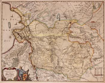
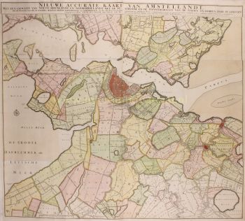
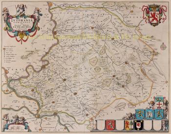
“Nieuwe Caarte van het Dykgraafschap van West-Friesland genaamt Geestmer-Ambagt, Schager en Niedorper Cogge” [“New map of the dyke district of West Friesland, called Geestmerambacht, Schagerkogge and Niedorperkogge.] Copper engraving drawn by cartographer Pieter Straat and engraved by Hendrik de Leth in Amsterdam, circa 1730. With beautiful original hand-colouring. Four joined sheets, together measuring 91 x 109 cm. In the Middle Ages, West Friesland was divided into four ambachten (districts). These were supra-local administrative units that likely existed even before West Friesland was brought under control by the Counts of Holland. Each ambacht in turn consisted of several coggen, which were further subdivided into bannen (villages or polders without a specific central village). This hydrographic map shows the three historical water boards: Geestmerambacht, Schagerkogge, and Niedorperkogge, which together formed the western part of old West Friesland. (In the eastern part of West Friesland were the ambachten of the Four Northern Coggen and Drechterland.) The cartouches on the map display the coats of arms of various villages located in the ambacht. On the left is the coat of arms of Geestmerambacht. In the center are the arms of Schagerkogge (Schagen, Barsingerhorn, and Obdam). On the right, finally, is the coat of arms of the dyke board of the Niedorperkogge, combining the arms of Nieuwe Niedorp (top), Winkel (lower left), and Oude Niedorp (lower right). A century before this map was made, a long-running legal battle played out between eastern and western West Friesland. The dispute concerned the apportionment of maintenance costs for the Westfriese Omringdijk, the great ring dyke protecting the entire region from the sea. The cost-sharing formula dated back to the 14th century and had become outdated. In the 17th century, following the reclamation of areas such as the Heerhugowaard, Schermermeer, Zijpe, and Wieringerwaard, the dyke in the western part of West Friesland was no longer directly exposed to the sea. As a result, maintenance costs there dropped significantly. Eastern West Friesland, however, continued to face the constant threat of the Zuiderzee. The eastern side demanded a revised cost allocation, arguing that a breach in the eastern dyke would also flood the western part. In 1637, eastern West Friesland brought the case before the High Council in The Hague. The lawsuit dragged on until 1695 and became known as the "Great Process" (Groot Proces). This situation is clearly illustrated on the map: the Westfirese Omringdijk is now surrounded by reclaimed land, and the seaward protection it once provided has diminished. The map also presents a finely detailed network of polders, ditches, canals, and dykes, complete with parcel indicators, field divisions, toponyms, and waterways. In several plots, letters and numbers appear - likely references to ownership or land use. The polder landscape reveals a carefully organized division of farmland, dyke routes, and buildings, a depiction vital to managing the vulnerable peat and clay soils. In the lower right corner, an large idyllic landscape scene has been added, with cheese production as its theme. A seated man rests atop a stack of cheeses, overlooking a classic polder view. In the 18th century, the peat polders of West Friesland developed into key areas for dairy farming, with cattle grazing on the soggy meadows. The milk produced was processed into Gouda-style (like Beemster) and Edam cheeses, which were traded and exported via local markets in places like Schagen, Hoorn, and especially Alkmaar. By the 18th century, Alkmaar had become a major hub for cheese trading, bolstered by its weekly cheese market where produce from the entire region was brought in. Small farming operations benefited from the area's navigable waterways, which allowed them to transport their goods quickly and efficiently. Thus, the watery landscape and peat meadows were essential to the region’s cheese trade and broader economy. Price: Euro 2.350,-