Original hand-coloured historical map of Asia 1630 - 1631
Jodocus Hondius
Papier
37 ⨯ 50 cm
€ 1.450
Inter-Antiquariaat Mefferdt & De Jonge
- Über KunstwerkEARLY DUTCH MAP OF ASIA “Asiae Nova Descriptio Auctore Jodoco Hondio.” Copper engraving made in 1628 by Jodocus Hondius for the "Atlas sive cosmographicæ meditationes de fabrica mundi et fabricati figura", here in a third state published in Amsterdam in 1630/31. Original hand-colouring with later additions. Size: 37.5 × 50.2 cm. This richly decorated map of Asia is among the most influential maps of the early seventeenth century. Its image reaches far beyond the continent itself: the map extends across the Pacific Ocean, showing the Philippines, New Guinea, and even part of North America. While the interior of Asia is still largely filled with names and geographical features that hark back to classical and medieval sources such as Strabo, Ptolemy, and Marco Polo, the coastlines reflect the most up-to-date information from late sixteenth-century Dutch cartography. The Indian subcontinent is drawn with remarkable accuracy based on the new sea charts published in Jan Huygen van Linschoten’s Itinerario (1596). In the north, Willem Barentsz’s discoveries around Nova Zembla are included and dated. Japan and Korea are depicted in the form already familiar from Abraham Ortelius’ famous 1584 map of Japan: Japan in a recognizable shape, but Korea as a large island. The southeastern part of the map shows Sumatra, the Malay Peninsula, the Philippines, and the Spice Islands in a reasonably reliable form for the time. New Guinea is accompanied by a Latin note stating that “it is not yet certain whether this is an island or part of a great southern continent.” In the northeast corner of the map appears the mythical "Fretum Anian" (Strait of Anian), which according to the Latin text might be the same as Davis Strait. This supposed connection between Asia and North America was thought by some to be the passage to the Northwest Passage. Hondius relates that attempts to explore the area had been made repeatedly, but always in vain: violent storms, the terrifying roar of the sea, and ice-covered mountains made every effort impossible. The map is not only a major geographical update of Gerard Mercator’s earlier map of Asia, but also an aesthetic masterpiece. Jodocus Hondius enriched it with an elegant strapwork cartouche, decorative rhumb lines, five sea monsters, and four ships that lend the map extra splendour. By combining classical knowledge, the latest discoveries, and a Baroque decorative style, this map stands as one of the most beautiful and influential representations of Asia in the seventeenth century. In the text block at the lower left, Hondius adds a concise description of the origins of the world’s peoples: “In Asia our first parents, Adam and Eve, were created by God. After the Flood, Noah’s Ark came to rest on the mountains of Ararat in Armenia, and from this place the world began anew in the following way: Noah had three sons, Shem, Ham, and Japheth. The descendants of Shem occupied the regions near the Euphrates, eastward. Ham went to the areas near the Jordan and the Nile, further southward. Japheth took Asia Minor, toward the west, and from there many nations spread into Europe (...). From these three lineages the principal nations of the entire world took their origin (...).” Price: 1.450,-
- Über Künstler
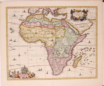
Jodocus Hondius (17. Oktober 1563 – 12. Februar 1612), auch bekannt unter der latinisierten Form seines niederländischen Namens Joost de Hondt, war ein flämischer Kupferstecher und Kartograf und eine der prägenden Figuren des Goldenen Zeitalters der niederländischen Kartografie. Um ihn von seinem Sohn zu unterscheiden, wird er oft als Jodocus Hondius der Ältere bezeichnet.
Hondius erlangte Berühmtheit durch seine außergewöhnliche Fähigkeit, technisches Können im Kupferstich mit geografischer Gelehrsamkeit zu verbinden. Er ist vor allem für seine frühen und einflussreichen Karten von Europa und der Neuen Welt bekannt, die das visuelle Verständnis der neu entdeckten Gebiete in Europa um die Wende zum 17. Jahrhundert maßgeblich prägten. Seine Karten zeichnen sich durch Klarheit, Präzision und detailreiche Dekoration aus – Eigenschaften, die sie sowohl zu maßgeblichen wissenschaftlichen Dokumenten als auch zu begehrten Kunstwerken machten.
Ein Wendepunkt in Hondius’ Karriere war der Erwerb der Originaldruckplatten von Gerardus Mercator. Zu einer Zeit, als Mercators Ruhm zu schwinden begann, veröffentlichte Hondius diese Tafeln neu und erweiterte sie, indem er seine eigenen Überarbeitungen und neu gewonnene geografische Erkenntnisse einfließen ließ. Dies belebte nicht nur Mercators Erbe wieder, sondern sicherte auch seinen nachhaltigen Einfluss und führte zu den berühmten Mercator-Hondius-Atlanten, die die europäische Kartografie über Jahrzehnte prägen sollten.
Neben der Kartografie war Hondius auch ein begabter Porträtstecher. Seine Porträts von Francis Drake zählen zu den bekanntesten Darstellungen des berühmten englischen Seefahrers und belegen Hondius’ Vielseitigkeit und seinen kulturellen Horizont.
Als eine der zentralen Figuren des Goldenen Zeitalters der niederländischen Kartografie (ca. 1570–1670) trug Hondius maßgeblich dazu bei, Amsterdam als führendes Zentrum der Kartografie im Europa des 17. Jahrhunderts zu etablieren. Sein Werk verband Kunst, Wissenschaft und Handel und prägte die Art und Weise, wie die Welt kartiert, verstanden und imaginiert wurde. Heute wird Jodocus Hondius der Ältere als Meisterstecher, innovativer Verleger und einer der wichtigsten Wegbereiter der modernen Kartographiegeschichte in Erinnerung behalten.
Sind Sie daran interessiert, dieses Kunstwerk zu kaufen?
Artwork details
Related artworks
- 1 - 4 / 6
Gobert Denis Chambon/ Jean Janvier, S.G. Longschamps
Magnificient antiek World map1754
€ 17.500Inter-Antiquariaat Mefferdt & De Jonge
Kuratiert vonDanny Bree
Unbekannter Künstler
Dutch School pair of equestrian paintings 1650 - 1750
Preis auf AnfrageGallerease Selected
1 - 4 / 24- 1 - 4 / 24
- 1 - 4 / 17
Gobert Denis Chambon/ Jean Janvier, S.G. Longschamps
Magnificient antiek World map1754
€ 17.500Inter-Antiquariaat Mefferdt & De Jonge
Kuratiert vonDanny Bree
1 - 4 / 24- 1 - 4 / 12


