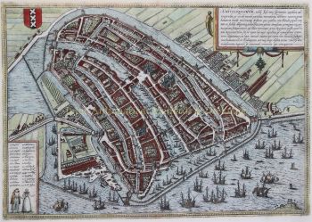
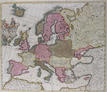
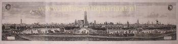
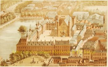
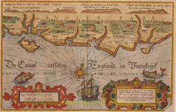
THE SEVENTEEN PROVINCES IN THE MIDST OF THE EIGHTY YEARS’ WAR “Inferior Germania”, copper engraving made by Jodocus Hondius the Elder in 1593, here in a second state (of four) published in 1608 as part of the "Commentarien onte memorien van-den nederlandtschen staet/handel/oorloghen ende gheschiedenissen van onsen tijden" [Commentaries or memoirs on the state, trade, wars and histories of our times in the Netherlands] by Emanuel van Meteren. Coloured by a later hand. Size: 39.5 × 55.5 cm. The map was made shortly before the Twelve Years’ Truce, in the midst of the Eighty Years’ War in which the Low Countries were entangled. On the verso side is a fascinating “Brief Description of the Dutch Map” ("Corte beschrijvinghe vande Nederlantsche Caerte"), here carefully transcribed and modernised: “The name ‘Netherlands’ comes from its low-lying position at the far western end of High Germany. From those higher lands, several major rivers descend, originating in the mountains, and eventually flow into the sea. These ‘Netherlands’—here meaning the collection of various autonomous provinces—once belonged to the Dukes of Burgundy, then passed to the Habsburgs, and subsequently to Emperor Charles V and his son King Philip. The term ‘Netherlands’ reflects the unification of these provinces under a single ruler. There was an attempt to make these provinces into a kingdom under the Burgundian crown. Although certain rights and freedoms were recognised, many towns and provinces resisted centralisation. Such attempts at domination, and the resistance they provoked, remain the cause of many wars to this day. The Netherlands is bordered by the North Sea, the county of Emden, the River Ems, Bentheim, Westphalia, the lands of Cleves and Jülich, the dioceses of Cologne and Trier, Lorraine and France. In other languages it is called ‘les Pays-Bas’ (French), ‘los Países Bajos’ (Spanish), or ‘the Low Countries’ (English), referring to its low elevation. The land measures approximately 340 Flemish miles in circumference and contains more than two hundred cities and around 1,500 villages—though many have been destroyed by the current war. Except in areas like Luxembourg, Liège, Namur and Hainaut, the landscape is predominantly flat. The soil is fertile, with vineyards, forests, pastures, fields, hunting grounds, and rivers and seas rich in fish. Fishing—especially in Flanders, Zeeland and Holland—is famous. The climate is generally mild, though fairly wet along the coast. Thanks to its strategic location, the Netherlands is well connected to the rest of Europe. Major rivers such as the Rhine, Meuse and Scheldt allow for intense trade. Maritime commerce is a major source of wealth; England, Norway, France, and even the distant Indies can be reached quickly. Shipping is highly developed. Hundreds of vessels engage in herring fishing alone. The Hollanders and Zeelanders are masters of seafaring, building, equipping and maintaining their ships with great skill. The population is generally tall, strong, industrious and intelligent. The origins of its people are debated: some say Jewish exiles, others Scythians, Greeks or Trojans. In any case, they are diligent, frugal and inventive. Their craftsmanship, trade acumen and thriftiness serve as examples to other nations. Their architecture, industry and navigation reflect a forward-thinking society. Most inhabitants speak Dutch (Diets), although many dialects are spoken. In the south, French and Walloon (‘a broken form of Latin’) are also common. According to some scholars, Dutch is an ancient language—richer than Latin and full of unique vocabulary. Julius Caesar praised the Batavians as the bravest people of Gaul. They hold fast to their faith and customs, resisting foreign influences such as those of Spain and the Jesuits. They would rather suffer than abandon their beliefs, as shown by their persistence during the present wars. The Netherlands is commonly referred to as the Seventeen Provinces, though not all are strictly separate provinces. Each has its own government and laws. They do not meet jointly, nor do they vote on central taxation. Around the year 1550, the Netherlands jointly consented to a monthly contribution of 300,000 guilders to Emperor Charles V. This tax was known as the ‘Novenrale’ (a term likely referring to division into nine instalments). The same levy was also called a ‘schenkschatting’, a financial gift formally presented as voluntary, but in reality a fixed obligation. This burden was primarily borne by Brabant, Flanders, Artois, Hainaut, Namur, Holland, Zeeland, Mechelen and Utrecht. Other territories like Luxembourg, Liège and Tournai were excluded. The Seventeen Provinces as shown on the map are, according to the most common enumeration: Brabant, Flanders, Artois, Hainaut, Namur, Luxembourg, Limburg, Holland, Zeeland, Utrecht, Friesland, Overijssel, Groningen, Mechelen, Guelders, Zutphen and Antwerp. This list follows ceremonial precedent rather than political importance. Not all these regions were truly autonomous: Zutphen was part of Guelders, Antwerp a margraviate within Brabant, and Mechelen a small lordship often treated as separate due to its legal and administrative significance. In this time, the Seventeen Provinces were divided into two political camps: Those still under the Spanish Crown, ruled by Archduchess Isabella Clara Eugenia; Those aligned with the States-General of the United Provinces, known as the Dutch Republic. The Spanish-controlled provinces included: Brabant, Limburg, Luxembourg, Flanders, Artois, Hainaut, Namur, Tournai, the Tournaisis, Mechelen and Valenciennes, along with parts of Guelders (e.g., Roermond and the Upper Quarter) and the lordship of Lingen. Not all these areas were fully under Spanish control at the time. The rebellious provinces included: the quarters of Guelders, Holland, Zeeland, Friesland, Utrecht, Groningen and the Ommelanden, Overijssel and Drenthe, as well as parts of Brabant and Flanders. These bore the collective burden of the war effort. Condition of the Provinces during Wartime: Artois, Valenciennes, Lille, Douai, Orchies, Tournai, the Tournaisis and Cambrai suffered heavily from the war: sieges, plundering, high taxation and occupation. Flanders was severely weakened. Cities like Bruges, Ghent, Ypres and Oudenaarde were besieged or in decline; some areas fell to the Republic. Holland remained strong, prosperous and largely untouched. The cities were well defended, trade and seafaring thrived, with Amsterdam and Rotterdam leading the way. Zeeland endured several sieges and deliberate flooding for defence, yet remained prosperous through trade. Vlissingen, Middelburg and Zierikzee were key centres. Friesland defended itself bravely despite major losses. Groningen and the Ommelanden were besieged and looted, forced to pay off enemies, but remained populated and intact. Overijssel and Drenthe were partly ravaged but retained self-rule. Utrecht suffered war damage, though key cities like Utrecht itself remained standing. Guelders was divided: some areas were under Spanish control, others with the Republic. Arnhem was in the hands of the States; many towns were fortified. Conclusion No other country in Europe has suffered more sieges, bombardments, fortifications, assaults, encampments, depopulation, disruption of commerce and naval interference than the Netherlands over the past 41 years. Yet they have retained their courage, strength and mercantile spirit. Due to their position between France, Germany and England, and their excellent harbours, they are admired and feared by many nations.” Literature: Hans Spikmans “Germania Inferior, cartobibliografie van de Zeventien Provinciën der Nederlanden 1548-1831”, map 32-2. Price: Euro 3.450,-