17TH-CENTURY UTRECHT 1652
Joan Blaeu
Papier
38 ⨯ 50 cm
€ 1.650
Inter-Antiquariaat Mefferdt & De Jonge
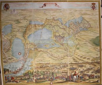
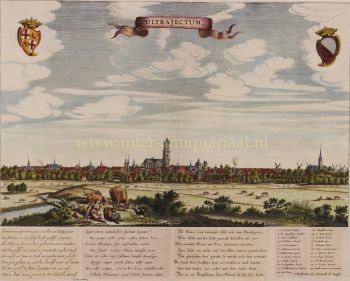
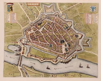
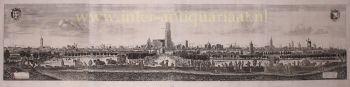
- Über Kunstwerk17TH-CENTURY UTRECHT “Traiectum Wttrecht,” copper engraving published by Joan Blaeu, ca. 1649 in his famous town book of the Netherlands: "Het Toneel der Steden van de Vereenigde Nederlanden met hare Beschrijvingen" [The Theatre of the Cities of the United Netherlands with their Descriptions]. Coloured by a later hand. Size approx. 38 × 50 cm. The copperplate from which the print was made must have been engraved between 1642 and 1649, since the Smeetoren, which was converted into an astronomical observatory in 1642, is indicated in the legend (no. 56) as “observatorium.” The map reflects the situation of 1642–1644, as the Pieterstraat—laid out in 1644—does not yet appear. The map contains several inaccuracies: the Salvatorkerk, already demolished in 1587, is still depicted; the Catharijne Gate is shown in its pre-1625 form; and the Vaartse Rijn and Oude Rijn are incorrectly oriented. After the founding of the university in 1636, the city created a sports field outside the city moat for the students, where the then-popular game of jeu de mail could be played (legend no. 53: Palle maille baen). With its six pall-mall players and rows of trees, the map provides a clear impression of this 17th-century recreation ground. The Amsterdam cartographer and publisher Joan Blaeu sought to fulfill the ambitions of earlier mapmakers Abraham Ortelius and Georg Braun & Frans Hogenberg by adding a series of city books to his multi-volume world atlas. Blaeu’s Toneel der Steden van de Vereenighde Nederlanden appeared in a Latin edition in 1649; the Dutch edition was printed in 1652. Some of the maps included in the work had already been published in earlier atlases—21, for instance, in Marcus Boxhorn’s Theatrum Hollandiae of 1632—while others were newly engraved specifically for Blaeu’s town book. It is known that Blaeu sent letters to city councils requesting that they provide him with a city plan and a written description to include in his work. Literature: “Kaarten van Utrecht” – Donkersloot de Vrij (1989), no. 14 Prijs Euro 1.650,-
- Über Künstler
Joan Blaeu (1596-1673), wurde am 23. September 1596 in Alkmaar geboren.
Er war ein niederländischer Kartograph, der in Alkmaar geboren wurde. Er trat in die Fußstapfen seines Vaters, des Kartografen Willem Blaeu.
1620 wurde er promovierter Jurist, trat aber in das Werk seines Vaters ein. 1635 veröffentlichten sie den Atlas Novus (vollständiger Titel: Theatrum orbis terrarum, sive, Atlas novus) in zwei Bänden. Joan und sein Bruder Cornelius übernahmen das Atelier nach dem Tod ihres Vaters im Jahr 1638. Joan wurde der offizielle Kartograf der Niederländischen Ostindien-Kompanie.
Blaeus Weltkarte Nova et Accuratissima Terrarum Orbis Tabula, die die Entdeckungen von Abel Tasman enthält, wurde 1648 veröffentlicht. Diese Karte war insofern revolutionär, als sie „das Sonnensystem gemäß den heliozentrischen Theorien von Nicolaus Copernicus darstellt, die zeigen, dass sich die Erde um sie dreht die Sonne .... Obwohl Kopernikus' bahnbrechendes Buch "Über die Revolutionen der Sphären" erstmals 1543 gedruckt wurde, war Blaeu etwas mehr als ein Jahrhundert zuvor der erste Kartograph, der diese revolutionäre heliozentrische Theorie in eine Weltkarte einfließen ließ."
Blaeus Karte wurde für die Weltkarte kopiert, die 1655 in das Pflaster des Groote Burger-Zaal des neuen Amsterdamer Rathauses eingelassen wurde, das vom niederländischen Architekten Jacob van Campen (heute Amsterdamer Königspalast) entworfen wurde.
Blaeus Hollandia Nova wurde auch in seinem 1659 erschienenen Archipelagus Orientalis sive Asiaticus im Kurfürsten-Atlas (Atlas des Großen Kurfürsten) abgebildet. und von Melchisédech Thévenot zur Erstellung seiner Karte Hollandia Nova – Terre Australe (1664) verwendet.
Als „Jean Blaeu“ veröffentlichte er auch den 12-bändigen „Le Grand Atlas, ou Cosmographie blaviane, en laquelle est Exactement descritte la terre, la mer, et le ciel“. Eine Ausgabe ist auf 1663 datiert. Das war Folio (540 x 340 mm) und enthielt 593 gestochene Karten und Tafeln. Im März 2015 wurde eine Kopie für 750.000 £ verkauft.
Um 1649 veröffentlichte Joan Blaeu eine Sammlung niederländischer Stadtpläne mit dem Titel Toonneel der Steeden (Ansichten von Städten). 1651 wurde er in den Amsterdamer Rat gewählt. 1654 veröffentlichte Joan den ersten schottischen Atlas, der von Timothy Pont entworfen wurde. 1662 gab er den Atlas Novus, auch bekannt als Atlas Maior, in 11 Bänden und einem für Ozeane neu heraus.
Als nächstes Projekt war eine Kosmologie geplant, doch 1672 zerstörte ein Brand das Atelier vollständig.
Joan Blaeu starb im folgenden Jahr, 1673, in Amsterdam. Er wurde in der Westerkerk in Amsterdam begraben.

Sind Sie daran interessiert, dieses Kunstwerk zu kaufen?
Artwork details
Related artworks
- 1 - 4 / 12
Unbekannter Künstler
Dutch School pair of equestrian paintings 1650 - 1750
Preis auf AnfrageGallerease Selected
1 - 4 / 24- 1 - 4 / 24
Jean-François Rauzier
Oasis Hotel - Limited edition of 8 2017
Preis auf AnfrageVilla del Arte Galleries
Cornelis Anthonisz Theunissen
SEHR SELTENE ERSTE GEDRUCKTE KARTE VON AMSTERDAM, EINER STADT AUF DEM AUFSTIEG1544
€ 125.000Inter-Antiquariaat Mefferdt & De Jonge
Kuratiert vonDanny Bree
1 - 4 / 24Rene Rietmeyer
"Japan, Tokyo, Kudan House" 20212021
Preis auf AnfrageEuropean Cultural Centre Collection
1 - 4 / 24- 1 - 4 / 12