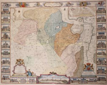
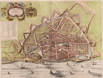
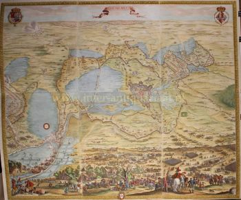
“Sylva Ducis Gallis vulgo Bois le Duc; vernacule ’s Hartogen Bossche” [Sylva Ducis, in French commonly called Bois-le-Duc; in the vernacular: ’s-Hertogenbosch.] Copper engraving published by Joan Blaeu in 1652 as part of his town book Tooneel der Steden. Coloured by a later hand. Size approx. 42.5 × 53 cm. The Duke of Brabant founded ’s-Hertogenbosch at the end of the twelfth century as the north-easternmost defensive outpost of his duchy. Because it lay near the “three-borders point” of Brabant, Guelders, and Holland, ’s-Hertogenbosch held great military importance for centuries. The city was provided with powerful fortifications and was almost impossible to conquer. During the Eighty Years’ War the Dutch States forces tried no fewer than six times—unsuccessfully—to capture it (in 1585, 1591, 1594, 1601, 1603, and 1622). The opposing side spent vast sums on improving and extending the fortifications. In 1629 Prince Frederick Henry besieged the supposedly impregnable city with 30,000 men; after three months it was forced to capitulate. Following the conquest, a massive citadel (or fortress) was built on the north side of the city. On the map (lower left) one can clearly see that the fortress commanded an open field of fire toward the city; the houses along the Orthenweg (“Casteels Pleyn”) were demolished for this purpose. The plan of ’s-Hertogenbosch shows that the city was laid out along three main streets radiating from the Marct veldt (market square): the Hinthamerstraat running east past St John’s, the Vughterstraat leading south, and the Orthenstraat heading north. The latter was later cut off by the citadel. To the west there was no direct road, but a city gate (no. 46, the St John’s Gate) gave access via the “Wech van Deuteren en Vlymen” along the “Newly Dug Canal.” On the reverse of the map Joan Blaeu described ’s-Hertogenbosch (in 1652): The desire for glory and honour, Blaeu writes, has always inspired men to great deeds—and to the founding of cities that would carry their names. Just as Alexander the Great gave his name to many cities, so ’s-Hertogenbosch derived hers from a duke, probably Godfrey III of Lorraine, who began building it in 1084. His son Henry strengthened the settlement with a moat and expanded it further. The city was originally circular and had three gates named after Leuven, Brussels, and Antwerp. Over the centuries ’s-Hertogenbosch underwent several enlargements—in 1318, 1453, and again in the early 16th century. It acquired brick walls, bastions, and deep moats fed by the rivers Dommel and Aa. Around 1550 it had seven city gates, later reduced to five: the Vughterpoort (to Antwerp), Orthenpoort (to Zaltbommel), Hinthamerpoort (to Grave), St John’s Gate (to Heusden), and St Anthony’s Gate (to Helmond and Eindhoven). Spanning the moats were dozens of bridges—according to Blaeu, 51 of stone and 38 of wood—and the city’s circumference was so large that it took a brisk walker an hour and a half to circle it. At the city’s heart stood the great St John’s Cathedral, elevated to episcopal status in 1559. Blaeu calls it “impressive and magnificent,” adorned with a costly clock. He describes the inhabitants as brave, martial, and industrious, retaining something of the sturdy character of the old Brabanders. At the same time, he praises their civility, diligence, and craftsmanship, noting the presence of many talented artists and artisans. ’s-Hertogenbosch lay in the midst of marshy terrain, surrounded by meadows often flooded—conditions that rendered it virtually impregnable in wartime. To the south, near Vught, where the ground was slightly higher, the Spaniards built three strong forts before the final siege of 1629: St Anthony, Isabella, and the Pettelaarse Schans. The Dutch Republic later further reinforced the city and constructed a new fortress at the end of the Orthenstraat, where the Dieze River enters the town. The municipal government consisted of two schouten (sheriffs) of noble birth—one responsible for civil matters, the other for criminal cases—and a board of schepenen (aldermen) elected annually. Emperor Charles V expanded this board in 1525 from seven to nine members and granted it considerable authority, including over fines and legal disputes. Only native citizens could serve as councillors, and they were required to reside in the city during their term of office. Blaeu calls ’s-Hertogenbosch the capital of the “fourth quarter” of Brabant, which included the regions of the Kempen, Peelland, Maasland, and Oisterwijk, with towns such as Helmond, Eindhoven, Megen, Ravenstein, and Grave. The city, he says, contained more than two thousand fine houses, a spacious market square from which eight streets radiated, and abounded in prosperity and artistic achievement. Finally, Blaeu lists several of its most distinguished sons: Cardinal Willem van Enckevoort, the humanist Georgius Macropedius, the scholar J(o)an van Vladeracken, and the jurists Dirck Nopen, Wilhelm van Veen, Arnout Arlen, and Gosuinus Steganus.
Together, he concludes, they embody the learning, courage, and excellence of a city which, “in strength, beauty, and fame,” scarcely finds its equal in Brabant. Price: Euro 1.450,-


























![RARE ARMORIAL MAP: LEO BRABANTIAE Lion of the most noble Duchy of Brabant] by Sibertus Waterloos](https://media-3.gallerease.com/images/325cc033-a3b6-495f-9da8-6d06caf29b14/350x350/rare-armorial-map-leo-brabantiae-lion-of-the-most-noble-duchy-of-brabant.jpg)